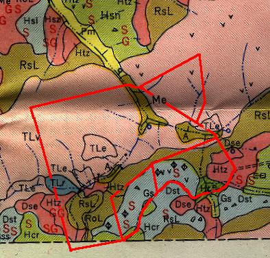
The black letters on the map refer to soil types, each of which is listed in the table below.
| Map
Symbol |
Soil |
Slope Range |
Internal
drainage |
Parent
Material |
Color of
subsoil |
General
productivity |
Land class |
| A |
Alluvial soils, undifferentiated |
0-3 |
Medium to slow |
Medium to moderately high |
Fourth |
||
| Dse |
Dunmore silty clay loam, eroded
steep phase |
30-60 |
Medium |
Residual material from weathered
limestone |
Yellowish brown or faintly
reddish brown |
Medium |
Fourth |
| Dst |
Dunmore silty clay loam, eroded
hilly phase |
15-30 |
Medium |
Residual material from weathered
limestone |
Yellowish brown or faintly
reddish brown |
Medium to moderately high |
Third |
| Gs |
Greendale silt loam |
0-5 |
Medium |
Local wash mainly from Elliber,
Clarksville, Dandridge, Lodi, and Westmoreland soils |
Brownish yellow, light brownish
yellow, or yellow |
Moderately high |
Second |
| Hcr |
Hagerstown silty clay loam,
eroded phase |
3-15 |
Medium |
Residual material from weathered
limestone |
Reddish brown to brownish red |
High |
First |
| Ht |
Hagerstown stony silt loam |
3-15 |
Medium |
Residual material from weathered
limestone |
Reddish brown to brownish red |
Moderately high |
Fourth |
| Htz |
Hagerstown stony silt loam,
steep phase |
15-60 |
Medium |
Residual material from weathered
limestone |
Reddish brown to brownish red |
Medium |
Fourth |
| Me |
Melvin silt loam |
0-3 |
Very slow |
Alluvium from uplands underlain
mainly by limestone |
Gray, spotted with brown or rust
brown |
Medium |
Fourth |
| RoL |
Rolling stony land (limestone
material) |
3-30 |
Medium to slow |
Medium to moderately high |
Fourth |
||
| RsL |
Rough stony land, limestone
material |
30-60+ |
Moderately low |
Fifth |
|||
| TLe |
Teas-Litz silt loam, eroded
steep phase |
30-60 |
Medium |
Residual material from weathered
shale and some limestone and sandstone |
Purplish brown, dark purplish
brown, or purplish red (Teas); light brown or yellowish brown (Litz) |
Moderately low |
Fourth |
| TLr |
Teas-Litz silt loam, eroded phase |
15-30 |
Medium |
Residual material from weathered
shale and some limestone and sandstone |
Purplish brown, dark purplish
brown, or purplish red (Teas); light brown or yellowish brown (Litz) |
Moderately low to low |
Fourth |
| TLv |
Teas-Litz silt loam, very steep
phase |
60+ |
Medium |
Residual material from weathered
shale and some limestone and sandstone |
Purplish brown, dark purplish
brown, or purplish red (Teas); light brown or yellowish brown (Litz) |
Moderately low to low |
Fifth |
A few symbols can also be found on the map. A diamond divided by a vertical line denotes a depression which is easy to cultivate across. A circle denotes a spring, while a small "v" denotes a rock outcrop.
Implications For Farming
Soil maps are most useful in determining which areas to use for agriculture. Each soil type is classified, ranging from first class soils which are good for both crops and pasture, to fifth class soils which are poorly suited to any sort of agriculture. Of the soils found at Wortroot, only Hcr (found on the southwest corner of the property) and Gs (found in a small patch along the road) are well suited for growing crops. Dst soil, found along Beech Bluff, is rated as poor to fair for crops and poor to good for pasture. The majority of the rest of the property is suited to pasture, with Middle Cave Ridge and Upper Cave Ridge unsuited to any form of agriculture.
Erosion
Red letters on the map refer to erosion at the time the survey was completed (in 1951):
S = Moderate sheet erosion
SS = Severe sheet erosion
SG = Moderate sheet and gully erosion
GG = Severe gully erosion
SS = Severe sheet erosion
SG = Moderate sheet and gully erosion
GG = Severe gully erosion
Since that time, the forest has grown up in most regions and has stabilized the soils. During this inventory, I did not notice erosion at the locations marked on the map. However, I did see two patches of erosion on extremely steep hillsides - on northwest Middle Cave Ridge and on the west side of Upper Cave Ridge. The erosion is currently minimal, but any type of disturbance to these areas, such as logging or road-building, would result in an erosion problem.
Further Study
I did not inventory the small animals found in the soil layer. In particular, millipedes reach a great diversity in our region and can be used as an indicator of soil depth and health. A survey of these invertebrates at a later date would be a useful addition to our knowledge of the property.
Source
United States Department of Agriculture. 1951. Soil Survey: Scott County, Virginia.
Questions or comments?
Email:


Last updated 9/04.

