Introduction
The southern Appalachians are sometimes referred to as a "temperate rainforest" due to their large quantity of rainfall. The wet conditions combine with many other factors to enhance the biological diversity of the region.
Looking at the smaller picture, a particular year's rainfall and temperature greatly affect the plants and animals of the area. During a drought year, frogs may not be able to breed or plants may not bloom; creeks may dry up and fish populations die. In contrast, during a wet year, floods may wash out creeks and erode the hillsides.
During this inventory, between September 3, 2003, and June 29, 2004, I recorded the temperature and precipitation daily near the farmhouse in Wortroot Cove. In the sections which follow, I have presented this climate data in relation to the typical climate data for the nearby town of Bristol, Virginia.
Temperature
During the inventory year,
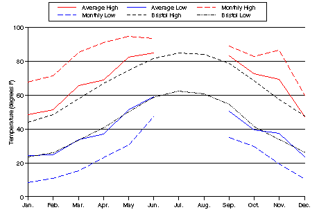
high and low temperatures were recorded daily. The colored lines
on the graph below show each
month's average high, average low, extreme high, and extreme low.
These can be compared to the average high and low for the Bristol area,
shown as black lines.
Temperature

As you can see, the average
monthly low
temperatures during the inventory were roughly equivalent to the usual
temperatures in Bristol while the average monthly highs were slightly
higher at Wortroot than usual.
Frost
The usual frost-free season for the region is 182 days long, extending from April 19 through October 18. During this inventory year, the first frost of the fall occurred early, on October 3, while the last frost of the spring occurred quite late, on May 4, resulting in a short frost-free season.
Rainfall
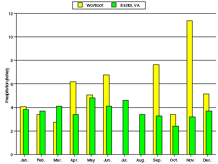
The year of the inventory was an exceptionally wet year. During the ten months when I gathered weather data, a total of 55.8 inches of precipitation fell at Wortroot. This is a foot and a half more than the average precipitation of 36.5 inches.
Total
Precipitation

A
large proportion of the rainfall fell during a few large storms,
several of which totalled two or more inches during a twenty-four hour
period. In November, one storm dropped over six inches in one
day. The heavy rainfall washed the creeks down to bedrock in many
places. This may have resulted in the lower than expected
diversity of macroinvertebrates in the creeks, as will be discussed in
the section on watersheds.
However, despite the overall wetness, late winter and early spring were unusually dry. This dryness fell at a critical time and may be the reason that little frog breeding activity was observed on the property during the study. We will discuss this hypothesis further in the section on amphibians.
Snowfall
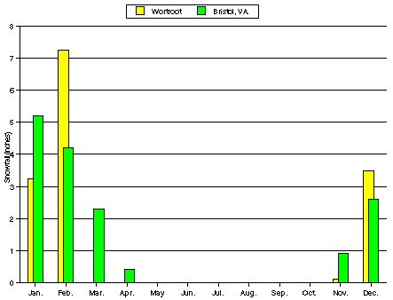
In the Bristol region, snow usually falls between November and April, totalling an average of 15.6 inches. During the inventory, 14.1 inches of snow fell, which is only slightly less than average. The pattern of snowfall during the year is shown in the graph below.
Snowfall


Sources
Climate data for Bristol, VA, comes from two sources:
United States Department of
Agriculture. 1951. Soil Survey: Scott County, Virginia.
Questions or comments?
Email:


Last updated 9/04.

